Area
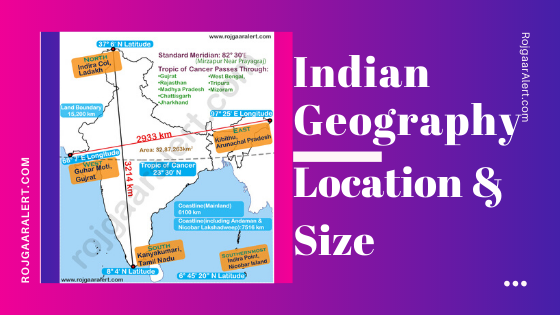
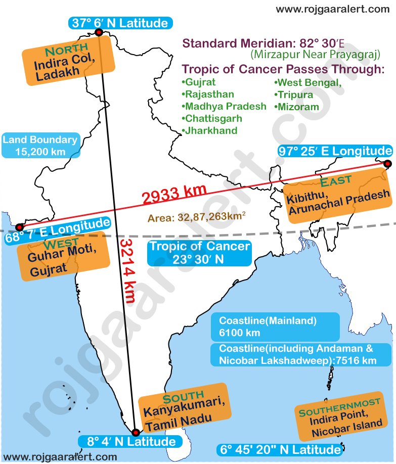
- Area of India: 32,87,263 km2
- India is the 7th largest country in the world (in Area).
- Distance from West to East of India: 2933 km
- Distance from North to South of India: 3214 km
- India’s total area is 2.4% of the total Geographical area of the world.
- Land Boundary or Terrestrial Boundary of India: 15,200 km
- Coastal Boundary of Mainland India: 6100 km
- Coastal Boundary of India including Lakshadweep and Andman & Nicobar Island: 7516 km
Location
- India lies in Northern Hemisphere.
- The main land extends between: 8°4’N and 37°6’N Latitudes
- And 68°7’E and 97°25’E Longitudes
- “Tropic of Cancer” (23.5 degrees) divides India into almost 2 equal parts.
- Standard Time Meridian of India passes through 82˚5′ E longitude (Mirzapur, near Allahabad)
- Northern Point of India: Indira Col, near Ladakh
- Southern Point of India(Mainland): Kanyakumari, Tamil Nadu
- Southernmost Point of India: Indira Point, Nicobar Island
- Western Point of India: Guhar Moti, Gujrat
- Eastern Point of India: Kibithu, Arunachal Pradesh
Neighbouring Countries
- These countries are neighbouring countries of India-
- Bangladesh
- China
- Pakistan
- Nepal
- Myanmar
- Bhutan
- Afghanistan
Bangladesh
- Border Length: 4096 km
- Bordering States: (1)West Bengal (2)Meghalaya (3)Tripura (4)Assam (5)Mizoram
China
- Border Length: 3488 km
- Bordering States: (1)Jammu and Kashmir (2)Himachal Pradesh (3)Uttarakhand (4)Sikkim (5)Arunachal Pradesh
Pakistan
- Border Length: 3323 km
- Bordering States: (1)Jammu and Kashmir (2)Punjab (3)Rajasthan (4)Gujrat
Nepal
- Border Length: 1751 km
- Bordering States: (1)Uttar Pradesh (2)Bihar (3)West Bengal (4)Uttarakhand (5)Sikkim
Myanmar
- Border Length: 1643 km
- Bordering States: (1)Arunachal Pradesh (2)Nagaland (3)Manipur (4)Mizoram
Bhutan
- Border Length: 699 km
- Bordering States: (1)Arunachal Pradesh (2)Assam (3)West Bengal (4)Sikkim
Afghanistan
- Border Length: 106 km
- Bordering States: POK
- Which neighbouring country of India share the largest border with India: Bangladesh, 4096 km
Tropic of Cancer
- The Tropic of Cancer (23° 30′ N) divides the country into almost 2 equal parts.
Tropic of Cancer passes through these Indian states:
- Gujrat
- Rajasthan
- Madhya Pradesh
- Chattisgarh
- Jharkhand
- West Bengal
- Tripura
- Mirzapur
Standard Meridian
- Standard Meridian of India is 82° 30′
- Standard Meridian of India passes from Mirzapur, Uttar Pradesh.
- India Standard Time (IST): +05:30 UTC
It passes through following states of India:
- Uttar Pradesh
- Madhya Pradesh
- Chhattisgarh
- Odisha
- Andhra Pradesh
Territorial Water Boundary
Territorial Sea
- Territorial sea is a belt of coastal waters extending at most 12 nautical miles (22.2 km) from Baseline.
Contiguous Zone
- Contiguous Zone is a belt of coastal waters extending at most 12 nautical miles (22.2 km) from Territorial Sea.
- It ranges from 12 nm from Baseline to 24 nm.
Exclusive Economic Zone
- An exclusive economic zone extends from the Baseline 200 nautical miles (370.4 km).
- It includes the contiguous zone.
Coastal States/UT of India
There are 9 Coastal States and 4 Coastal Union Territories of India.
- Length of Total Coastline of India 7516.6 km including Lakshadweep and Andaman & Nicobar Island.
- Length of coastline of Mainland India is 6100 km.
- Largest Coastal Line of India is Gujrat.
Coastal States of India:
- Gujarat
- Maharashtra
- Goa
- Karnataka
- Kerala
- Tamil Nadu
- Andhra Pradesh
- West Bengal
Coastal Union Territories of India:
- Daman & Diu
- Puducherry
- Andaman & Nicobar Islands
- Lakshadeweep
Important Points
- Barren Island (Andaman) is only active volcano in South Asia and India.
- Lakshadweep is the Smallest Union Territory of India.
- Kavaratti is the administered capital of Lakshadweep.
- 8° Channel separates Minicoy and Maldives.
- 9° Channel separates Lakshadweep from Minicoy.
- 10° Channel separates Andaman Islands and Nicobar Island.
You may also like:
General Knowledge
Indian Geography – Size and Location
Books and Authors List
Important Days and Dates
Computer Related Full Forms
Popular Indian Authors and Their Books
Most Important Full Forms
Science-related full forms
Computer Related Full Forms
Atom and Molecules
List of National Parks of India
List of Bharat Ratna Award Winners
Mathematics
Basic Maths Formula Collection
Syllabus
SSC CGL Syllabus
Quiz
Important Days and Dates
Indian Art and Culture
Computer Basics
Indian Constitution
World Geography
Indian Geography
Current Affairs